I still have to pinch myself every once in a while. The letter came, letting me know I had the job conducting research at Grand Canyon. Six months. The question: How did people hiking the backcountry feel about the routine, and during the day almost incessant, aircraft flights above their heads. Fixed wing aircraft, helicopters, and even jets from nearby Air Force and other military bases. Even jet vapor trails from large airliners scored the sky, irritating some photographers no end. The place was abuzz, and I quickly discovered not everyone was happy that I, or anyone, was on this task. I was to be a GS-1 – the lowest pay grade on the Federal Government’s “General Schedule.”
I was ecstatic. I’d been to the Canyon before, my senior year at West Virginia University. I was beyond eager to return.

In my senior year at WVU, we had a recent graduate, and newly minted Park Service Ranger, who offered to host a crew of seniors from our school, along with our beloved professor, “Hutch.” Joe Hutchison was the best instructor I could have wished for on this challenge. If needed, I would have carried him out of the Canyon.
There must have been about ten of us on the team from WVU. We all fit in a van on the way from Sky Harbor, the aptly named Phoenix airport. I remember it being my first trip sitting next to someone spitting a regular stream of tobacco juice into a can. It was a unique start.
I had grown up back east, and truly did not appreciate, until that trip, the ways the arid west displayed its rocky contours. Layers bending and wrapping around others, and the dry arroyos of the desert. Massive cacti seeming to wave at passing traffic. It was an exposed and harsh landscape, and because it was so different from my lush green homeland, I was fascinated by its beauty. Tres formidable!
After rolling through the harsh Sonoran desert, we charged up a steep incline, the highway to the top of the Mogollon Rim and the town of Flagstaff, the home of Northern Arizona University. Cooler, with conifers clustered about the high desert, this was a lovely respite from the heat below. After a fast and unmemorable meal, we headed out across the plateau, past some major volcanic cones and sparse habitation.
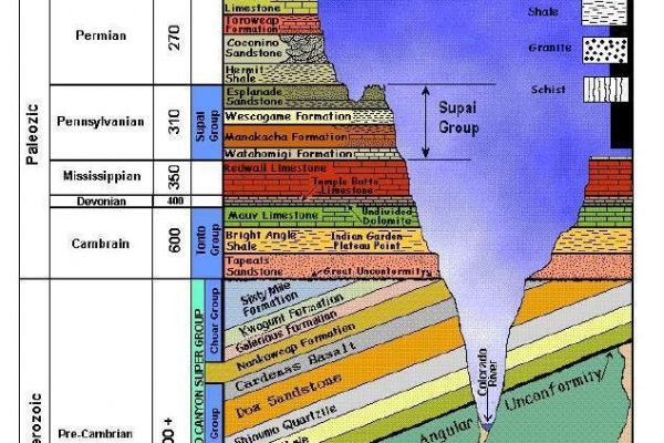
We finally pulled past the entrance to the Park after a brief discussion with the fee collectors, and another sign reading “Park Residents Only” into Albright Conference Center, a training hub for the National Park Service. Next to the training complex stood a series of two story apartment blocks with massive rough-hewn furniture, familiar to those who have experienced college dorms. But this one hosted mule deer grazing between those residential blocks, had a thick pine tang in the dry heat, and was landscaped with the white Kaibab limestone that is the upper crust of Grand Canyon’s great geo-cake. Grasshoppers buzzed to catch any lift in the thin atmosphere.
I could not help it. I had rim fever.
We hiked down to the rim as a group that late afternoon. I was stunned, even knowing from a million photographs what to expect. It was, will, and will always remain amazing. The vast emptiness just below you, stretching out to dusk. Bats. Plump ravens, living large on tourist scraps. Peregrine falcons. And the depths.
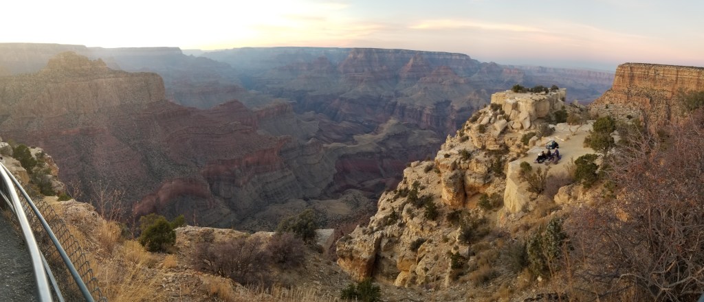
It is one of the few places where one desperately wanted to fly. Not with an airplane; but as if transformed to an eagle – or heck, one of those ravens. To soar on the thermals and drift past the massive cliffs.
I hear the Navajo Nation is considering an aerial tramway in the eastern Canyon to generate tribal revenue. I believe if they just set up a paragliding launch pad on the rim they could do just as well with far less impact. There may be a few more pieces to pick up, but what a ride!
We were planning to hike down to Phantom Ranch at the bottom of the Canyon after several days on the edge, discussing wilderness resource management with Park Service staff in South Rim Village. It was a school trip, after all. I remember futzing with Velcro during our information sessions, trying to seal up a poncho I was worried left me too exposed to the elements. I needn’t have worried; rain wasn’t in the forecast.
We learned about the vast array of Anasazi cultural artifacts spread about the Canyon. We discussed the venture by a one-armed Union Army major, John Wesley Powell, and his team to take fishing dories on the first trip down the Colorado River (by white men) at its wildest, before the Glen Canyon Dam regulated flows. We learned of pinyon pines and prescribed burns, campsite monitoring and maintenance and wilderness use permits. It was a very busy place. However, what we did not discuss at any length were the aircraft.
As the hike approached, we were all a bit nervous. It was a seven mile hike down the South Kaibab Trail, the shorter but more exposed route down to the Ranch. Most folks headed down Bright Angel Trail, a serpentine route just below the Bright Angel Lodge, El Tovar Hotel and the other historic structures at South Rim Village. The Bright Angel trail had three locations on the way down where one could get water. It also had a lot of foot traffic, including the mules that patiently hauled smiling tourists in and out of the Canyon. The local joke was that the mule riders headed down with big smiles, and came back to the rim with pained grimaces, while the situation for hikers was reversed. Most posteriors don’t survive long rides in a mule saddle unscathed.
And where go mules… The trail has frequent mule-pies and puddles. The mule is a creature of habit, and group habits at that. Where one decides to let go, others will surely follow. The pools on the Bright Angel can get pretty deep, and ripe.
On the South Kaibab Trail, however, the only mules allowed were the Park Service pack mules, headed down to Phantom Ranch to resupply the backcountry. The trail itself was two miles shorter, but – no water until one got to the Colorado River.
The night before we were to head down, we had a small party. At the end of the evening, folks drifted off to their beds – and left me alone with a lovely young lady I had been dazzled by the entire trip. Golden curls, a cute smile, and eyes one could fall into and disappear. She had been a senior at WVU the year before, but had joined the trip – to my delight. I had been gazing at her in love-struck wonder through the planning meetings and most of the way west; a mongoose to her cobra, or perhaps the other way around.
As a West Virginia buddy of mine would have quipped, “I wouldn’t kick her out of bed for eatin’ crackers!”
That night – alone at last – I was too shy to make my move. I could say that it was just a case of nerves about the hike the next day, but the truth is I was just too shy, afraid of how she might respond. I’ve occasionally wondered how that one evening might have changed my life, but it was not to be. Faint heart ne’er won fair lady. Of course, I would not have met my lovely current wife, had two charming sons, and shared a blessed life with her. Fate.
We started down the trail the next morning, and I remember how difficult it was to keep one’s eyes on the trail at one’s feet. The views were stunning, and we had to take frequent gazing breaks. Because the trail was along a ridge, some of the views were almost straight down. Yet the trail stepped slowly but surely down, zigzagging the vertical mile into that vast space.
While I tried to catch her eye, my amour must have decided I was all eyes and no action. I was kicking myself halfway down the trail.
We edged down the “Redwall;” a gigantic limestone cliff looming over the Tonto Plateau, a band of slightly more level terrain shelved above the Inner Gorge. We stepped down, and down, and down again, over and over, with a pack loaded with water sloshing around behind. We paused on the Tonto, grabbing lunch and gazing up at the walls that now rose around us. The vastness of the place had begun to sink in. And the strain that stepping down again and again posed to feet, ankles, and oh, yeah – those knees, was evident. This was mountain climbing in reverse.
Dropping into the Inner Gorge, our trail led down steep cliffs made up of the oldest and deepest layers of the Canyon. Vishnu Schist, Zoroaster Granite, Tapeats Sandstone, twisted in bent and broken ledges and seams that had been laid down long before the layers of the Upper Canyon had settled into place. The Colorado River, carver of canyons, flowed below us, crossed by a spooky-looking cable bridge leading to the north bank of the River and Phantom Ranch.
Phantom Ranch has a small campground, built along the lovely stream flowing in from the north. It has several bunkhouses, a stable, and serves as a Park Service field office. It is desert terrain, being one mile lower in elevation from the rim – and sunlight is a scarce resource. Large cottonwood trees thrive from the waters of Bright Angel Creek, providing shade and a gentle rustling sound. It is a sweet oasis.
We spent the night at the Ranch, enjoying a hearty meal that “stuck to the ribs” and that had probably been served for the last 100 years. We attended the campfire program, learning some local history, and discussed the Anasazi, who inhabited the Canyon for hundreds of years until they mysteriously disappeared. Famine? War? It was a historic puzzle.
We bedded down in the bunkhouses (one for men, another for the women) and had a great night’s sleep, despite a few sore muscles.
The next day, after another hearty meal, we headed up the Bright Angel Trail, taking the longer route with water stations. I remember being surprised at how much easier it was stepping UP, and carrying less water. Even the mule pools did not seem too bad.
Once we climbed out of the Inner Gorge, we encountered a polyglot stream of hikers, milling about the Indian Gardens outpost. It was clearly THE place to hike if you just had a few hours off the bus.
Too soon, we were back at the Rim, and the hike seemed more dream than memory.
The rest of the trip went quickly. We headed out of the Park, down into the beautiful Red Rock area of Sedona and stopped at Tlaquepaque, a pseudo-Mexican shopping complex designed to collect cash and reduce fears of Montezuma’s Revenge. I kept looking back at the Mogollon Rim, the gigantic cliffs that displayed many of the same rock layers of the Grand Canyon, but now hid it from view.
Yes, I had been to the Canyon before, but I was more than ready to go back!
